Mapping for China urban extent from satellite data
-
The Defense Meteorological Satellite Program's Operational Line-scan System (DMSP-OLS) nighttime light (NTL) images
have been proven to be a reliable data for mapping urban areas at regional or global scales.
Here we propose a novel index, called normalized urban areas composite index (NUACI),
to obtain accurate and timely information about urban dynamics in large areas based on combination of DMSP-OLS, MODIS EVI, and NDWI.
The innovation of NUACI is that it can significantly reduce the effects of the NTL blooming and saturation in urban areas.
Furthermore, the index is simple to implement, and has ability to extract urban areas timely at a large area with reasonable time, limited labor, and low cost.
Then, China was selected as the case study because it has been experiencing unprecedented urbanization with rapid economic growth over the past three decades.
Landsat ETM+ images were used for extracting urban areas in the selected sites at the local scale. DMSP-OLS, MODIS EVI, and NDWI were integrated to calculate NUACI value,
which was used to estimate impervious surface area by using a regression model with the combination of ETM+ derived urban areas.
-
Interest in mapping impervious surface area (ISA) at regional and global
scales is increasing because monitoring urban dynamics is crucial for
understanding global urbanization and its environmental and ecological
consequences. DMSP-OLS nighttime light (NTL) data has been proven to be
successful for mapping urban land in large areas. However, the well-documented
issues of pixel blooming and saturation limit the ability of DMSP-OLS data to
obtain accurate urban areas information. Here a multi-source composition index
is proposed to overcome the limitations of the NTL data. Three data source
including DMSP-OLS, MODSI EVI and NDWI are combined to generate a new index,
called normalized urban areas composite index (NUACI), which aims to quickly map
impervious surface area at regional and global scales.
Here we provided a promising approach to estimate ISA at global scale by integrating multi-source images with medium spatial resolution.
The proposed NUACI index is simple to implement, and is especially valuable for extracting urban areas timely at large areas.
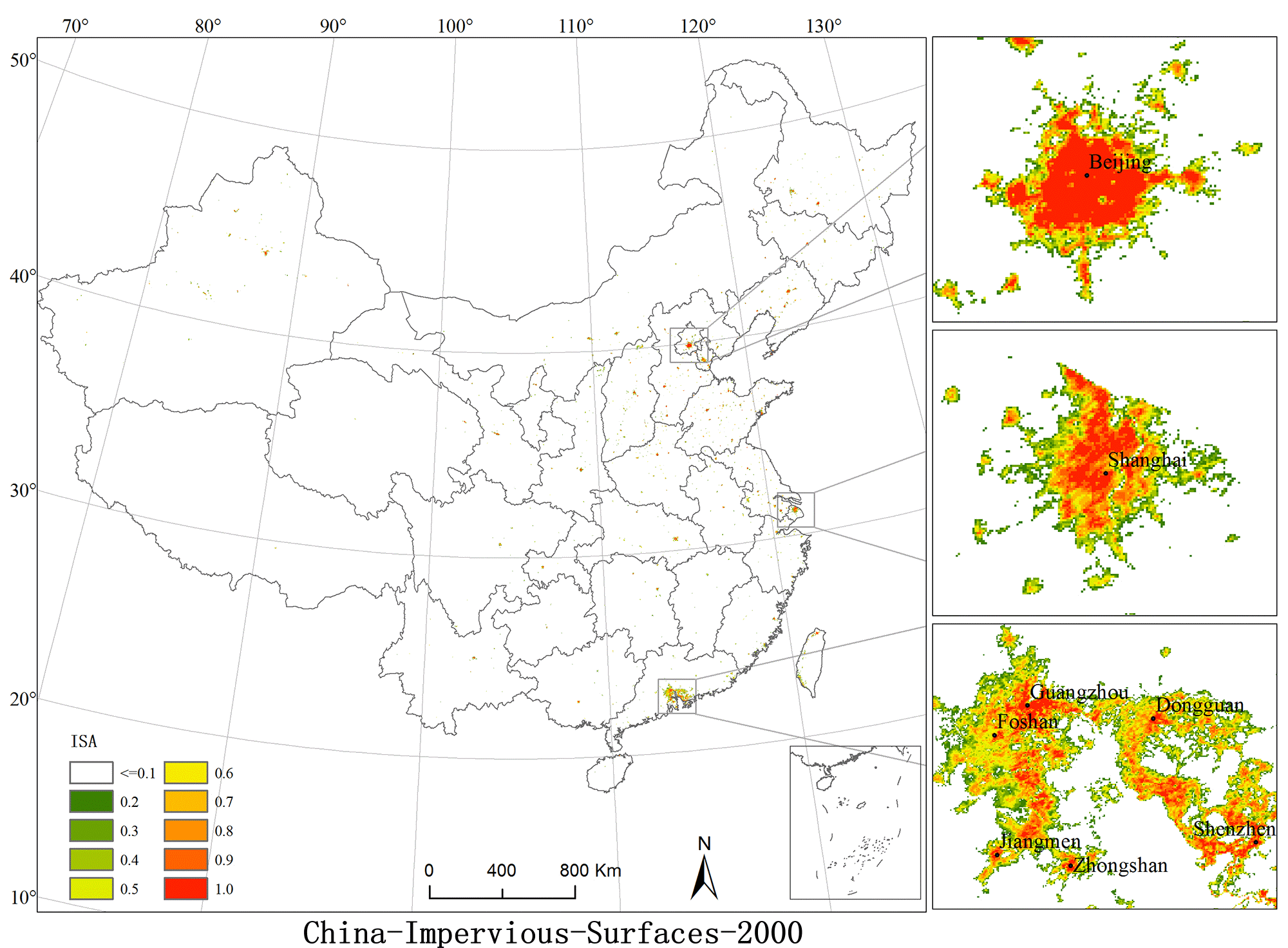
Lastly, the NUACI based regression models were used to map impervious surface area for the whole China in the years of 2000, 2005 and 2010 (available at http://www.geosimulation.cn/ISA-China.htm ).
Downloading the data
-
All data are available for download at:
China-Impervious-Surfaces-Percentage(2000,2005,2010),(format=TIF,RAR)
Description of the dataset: Readme
Contact information
-
All comments, questions and concerns should be directed to:
Liu Xiaoping
Professor,Geography and Planning School of Sun Yat-Sen University
135 West Xingang RD., Haizhu District
Guangzhou, P.R. China
Zip code: 510275
liuxp3@mail.sysu.edu.cn
Reference
Last updated: 25 February, 2014