Geographical Simulation and Optimization System (GeoSOS)
The continuous strengthening of human activities and intensification of climate change have jointly affected global land cover changes. Scenario-based land change simulation has been widely used as a powerful tool that can assess the impact of potential land changes. However, the current future land projection products at a global scale generally suffer from deficiencies such as low resolution, unsuitable scenarios, and few types of land. Therefore, we propose a series global land projection datasets with a resolution of 1-km from 2015 to 2100, which uses the latest IPCC coupling scenarios of socioeconomic and climate change, SSP-RCP.
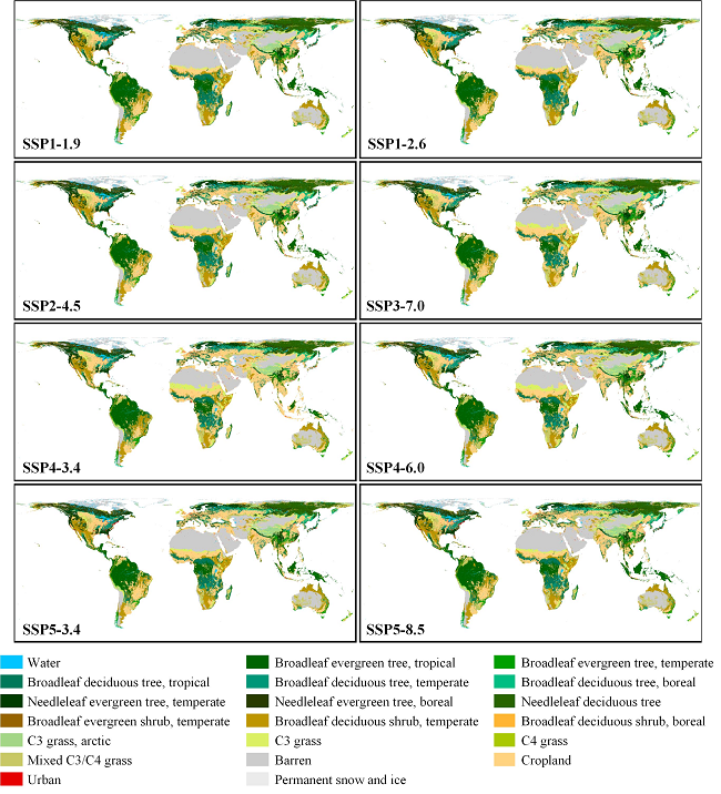
Actually, there are two subdatasets: 1) the 1-km global land-use/land-cover (LULC) dataset containing seven land types; 2) the 1-km global PFT-based land dataset containing 20 land types. The production of the LULC dataset combines the top-down land demand constraints provided by the official dataset of CMIP6 and the bottom-up spatial simulation executed by cellular automata (CA). The land demand from official data sources ensures the authority of the land trajectories under different SSP-RCP scenarios. The CA model is executed separately in different regions of the world to reflect spatial heterogeneity. According to climate data, we further subdivide the LULC dataset's land types into 20 PFT-based (Plant Functional Type) types, which can better meet climate models' needs for input data. The results show that our global land simulation achieves a satisfactory accuracy. The spatial change of various land types in each scenario appropriately reflects the storyline of the corresponding scenario. We believe that our dataset can provide stronger data support for climate research, including climate models, due to its advantages in resolution, scenarios, and land types.
Global LULC dataset containing 7 land types at a 1-km resolution under the SSP-RCP scenarios for 2015 - 2100 are available to download in: Here
Global PFT-based land dataset containing 20 land types at a 1-km resolution under the SSP-RCP scenarios for 2015 - 2100 are available to download in: Here
Guangzhao Chen, Xia Li & Xiaoping Liu*. 2022. Global land projection based on plant functional types with a 1-km resolution under socio-climatic scenarios. Scientific Data, . 9: 125. https://doi.org/10.1038/s41597-022-01208-6.
If you have any comments and suggestions, please contact Prof. Xiaoping Liu: Liuxp3@mail.sysu.edu.cn
Last updated: 11 March, 2021